
ACRE Update — July 2025
Executive Summary
This report covers the 2025 dry season (December 2024 - May 2025), which presented significant operational challenges, primarily from severe wildfires that led to unprecedented losses in natural capital. In response to this, we have implemented a strategic pivot in our planting methodology to accelerate canopy growth. Key developments in this period include:
Record Wildfire Losses: Over 5,000 trees were lost, a significant increase from previous years, as the threat from local agricultural practices remains high.
Performance Analysis: An initial survey reveals only 25% to 30% of our initial pioneer trees are on track to form a canopy by year four.
Strategic Pivot: Introduction of a fast-growing, nitrogen-fixing species, Leucaena leucocephala, to replace losses and underdeveloped trees.
Land Tenure Challenges: The Community Forest registration process remains stalled due to local land speculation. We are now pursuing an alternative legal strategy to secure the project site.
New Partnership: We are pleased to announce a new sponsorship from the Myanmar Ultra Trail Running Association (MUTRA), providing financial support and increased project visibility.
1. Operational Review: 2025 Dry Season Wildfires
The 2025 dry season was the most destructive to date. Wildfire losses have escalated dramatically compared to previous years:
2023 Season: ~800 trees lost
2024 Season: ~800 trees lost
2025 Season: >5,000 trees lost
The primary cause remains traditional slash-and-burn agriculture on adjacent fields. In March 2025, a planned burn coincided with unexpectedly high winds, which carried embers across our firebreaks and overwhelmed our on-site fire-fighting team. This single event resulted in the loss of approximately 4,000 trees in Area 2, mitigated by aid from our staff and several community members.
-
ACRE Myanmar operates within a severely degraded ecological landscape, a direct result of extensive regional deforestation over the past five decades. This environmental damage has disrupted the natural hydrological cycle.
Healthy forests release significant atmospheric moisture through evapotranspiration, a process that helps generate localized rainfall and maintains soil humidity. The widespread loss of this forest cover has created a harsh microclimate at the project site, characterized by an extreme dry season with zero precipitation from approximately October to May.
This context presents the primary operational challenge for our reforestation efforts and underscores the critical importance of our endeavour.
Significant barriers to rehabilitation persist among local communities, many of which persist in periodic burning of crop stubble to fertilise their fields in addition to using chemical fertilisers.

Fire fighting with a 2-stroke engined blower.
Please see our reports for March 2024 and May 2023 for a detailed account. Every year, we’ve replanted new trees of the same species during the following monsoon.
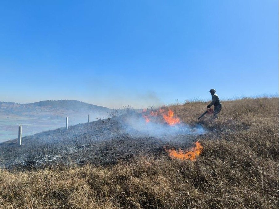
A worker combats fires propagated by strong winds.
2. Tree Growth and Survival Survey
We conducted a comprehensive survey of our 2022 pioneer plantings to assess their viability for canopy formation by year four. Trees were categorised by height:
● Normal Growth (>1.2 m): On track for canopy formation.
● Slightly Small (0.6−1.2 m): Require intervention.
● Too Small (<0.6 m): Non-viable; require replacement.
● Deceased (Wildfire/Other): A loss.
This revealed that only 7% of the trees planted were deceased. Two years later, an iterative survey showed that this figure was 11%, which was considered a satisfactory performance by research bodies.
We have now improved upon these surveys to account for tree height. This survey revealed that only 25-30% of the original pioneer trees have achieved the target growth rate. The remaining 70-75% are either deceased (primarily due to wildfires) or underdeveloped, placing pressure on the project timeline for canopy closure.
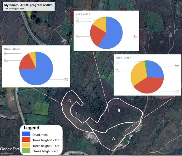
Area 1
Zones A & B show a majority of healthy trees. Zone C shows poor performance, with two-thirds of trees either deceased or too small.

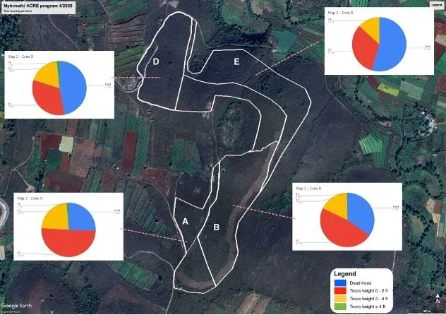
Area 2
This area was most affected by the 2025 wildfires, with a majority of trees lost in zones D and E. The remaining sections are dominated by underdeveloped trees.
Area 3
Zones B and C suffered significant fire damage. Zone A, protected by a road, has performed well.
3. Introducing a Fast-Growing Pioneer Species
To address the growth gap and accelerate canopy formation at our sites, we have identified and are now introducing Leucaena leucocephala (the "Leadtree"). This nitrogen-fixing species has the advantage of being native to the region, demonstrates exceptional growth rates (often reaching 4 meters in two years), and is well-suited to harsh conditions.

A 4 year old Leucaena.
The timber Leucaena produces is not of exceptionally high value, but is used by some farmers for pole fencing.
We have also established a nursery to produce 25,000 Leucaena seedlings. Planting is underway from July to September 2025 to replace all non-viable and deceased trees. This intervention is designed to rapidly establish shade cover, a critical step for the subsequent introduction of other native forest species.

A cow foraging on Leucaenae near Myinmethi village.
4. Land Tenure and Improved Risk Mitigation
Our efforts to register the reforested area under a “community forest” tenure have encountered significant administrative hurdles in the past. Despite meeting all procedural requirements with Myanmar’s Forest Department, final approval has been repeatedly stalled at the township level.

Forest Department officials inspecting the Myinmethi site on 25 March 2025.
Analysis, supported by expert consultation with NGOs, indicates that these setbacks are linked to rising land values and speculation in the Kalaw region due to its rising status as a tourism destination.
To secure the project site, we are initiating an alternative legal “claim procedure”, which, while can be lengthy, grants our bid administrative priority and protects the land from contestation. This strategy, we believe, can be a crucial safeguard for our investment while we continue to attempt Community Forest registration in a more favourable political climate.
5. Better Planning with Environmental Data
Drone technology is changing how we approach project planning and environmental management. By deploying drones equipped with specialized sensors, we can generate a suite of powerful data layers that provide an unprecedented, multi-dimensional view of a project site.
The foundation is the orthophoto, a high-resolution, geometrically corrected aerial map. Unlike standard satellite images, this provides us with a detailed and up-to-date visual record, allowing for precise tracking of assets and a basis for verifying site conditions.
In addition, the Plant Health map, using the Normalized Difference Vegetation Index (NDVI) lets us visualise vegetation vitality by measuring how plants reflect light, revealing stress from factors like drought or nutrient deficiency at scale. The Terrain Height model provides a detailed 3D map of the local topography.
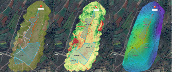
3 layers from left to right of ACRE Myanmar’s Site 1: (1) a drone orthophoto, a geometrically corrected aerial photograph); (2) plant health, specifically an index called the Normalized Difference Vegetation Index, which relies on the fact that healthy vegetation absorbs most of the red light and reflects a large amount of near-infrared light; and (3) terrain height.
When used together, these layers allow us to better plan and operate. For instance, by overlaying plant health data on the terrain map, we can identify erosion-prone areas (e.g., steep slopes with poor vegetation cover) or understand why certain plantings may be failing (e.g., due to poor drainage in low-lying areas).
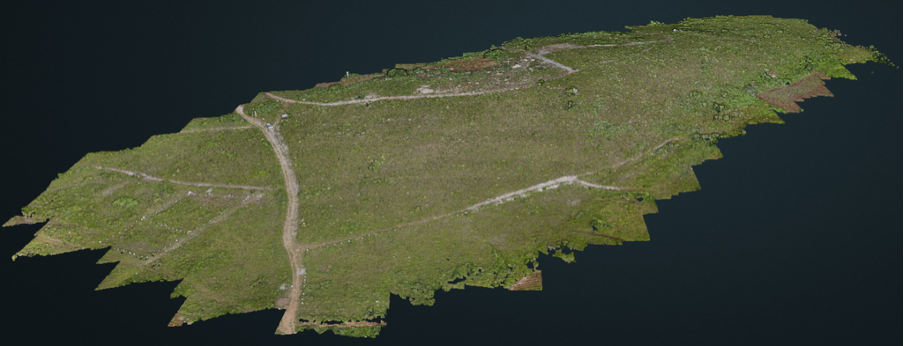
A 3D terrain map of ACRE Myanmar Myinmethi’s Site 1.
This allows for targeted interventions, saving time, reducing costs, and improved ecological outcome, and a proactive approach ensuring resources are deployed effectively to realise ACRE Myanmar’s vision. Our files are available for download through this Google Drive link.
6. Stakeholder Engagement and A New Partnership
A meeting in May with over 50 community members in attendance was held to report on progress and discuss fire prevention. The community expressed growing support, acknowledging the project’s benefits and committing to optimise coordination on agricultural burning, and surprise over the viability of the nascent forest. Initial suspicions of land-grabbing have been successfully dispelled.

Director Philippe Lenain addresses the Myinmethi community.
A new sponsor
We are pleased to announce a strategic partnership with the Myanmar Ultra Trail Running Association (MUTRA). MUTRA is a social enterprise in eco- and sports-tourism, promoting trail running as a platform for environmental action, community engagement, and eco/sports tourism. They are behind some of the highest profile events of their kind nationally, including the Popa Jungle Trail Run and the Kalaw Ultra Trail Run. MUTRA will support ACRE Myanmar through its “Trails for Trees” initiative, donating a portion of its membership revenues, providing valuable financial support and visibility, with plans to route a future trail through our plantations.
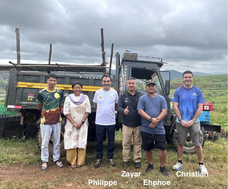
Zeyar and Christian visit the Myinmethi project in July 2025.